This map has three different types of information.
HISTORY OF COUNY BOUNDARIES The land that currently makes up Lake County has been divided into regions, designated by the capital letters
A,B,C, etc. A summary of each region's county affiliation follows:
A : 1821 St. Johns Co.; 1824 Mosquito; 1845 renamed Orange; 1887 Lake
B: 1821 St. Johns Co.; 1828 Indian Lands; 1834 Hillsborough; 1844 Mosquito; 1845 renamed Orange; 1887 Lake
C: 1821 St. Johns Co.; 1828 Indian Lands; 1834 Hillsborough; 1844 Marion; 1853 Sumter; 1872 Orange; 1887 Lake
D: 1821 St. Johns Co.; 1828 Indian Lands; 1834 Hillsborough; 1844 Marion; 1853 Sumter; 1887 Lake
E: 1821 St. Johns Co.; (1824-1828 a narrow strip along the northern border was Alachua); 1824 Indian Lands; 1834 Hillsborough; 1844 Marion; 1853 Sumter; 1887 Lake
F including the notch: 1821 St. John Co.; 1824 Indian Lands; 1834 Hillsborough; 1866 Sumter; (1871-1879 a narrow strip along the southern border including the notch was estimated and a part of Polk Co.); 1887 Lake; 1891 the notch area became Polk Co.
Protrusion from T22S R26E: 1821 St. Johns; 1824 Indian Lands; 1834 Hillsborough; 1844 Mosquito; 1845 renamed Orange; 1887 Lake.
Small area near intersection of B, C, D, E: gained from Orange in 1889.
top
Land record description and sometime other descriptions of location use the township nomenclature, so that information has also been added to the above map ( along the west and south edges of the county). The Township designation looks like this: T18S R26E.
Each 6-mile-square township shown on the map above is further divided into 1-mile-square Sections that are numbered as shown here:
| 6 |
5 |
4 |
3 |
2 |
1 |
| 7 |
8 |
9 |
10 |
11 |
12 |
| 18 |
17 |
16 |
15 |
14 |
13 |
| 19 |
20 |
21 |
22 |
23 |
24 |
| 30 |
29 |
28 |
27 |
26 |
25 |
| 31 |
32 |
33 |
34 |
35 |
36 |
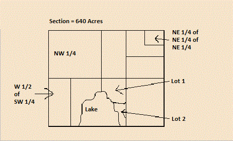
It is the Section that is further broken down by the familiar NW 1/4 of the SW 1/4 of the NE..........etc.
Sources:
The Source by Arlene Eakle & Johni Cerny
Atlas of Historical County Boundaries. Florida John H. Long, Editor; Compiled by Peggy Tuck Sinko and Kathryn Ford Thorne
Plat Directory Lake County Florida 1979 Published by The Great Mid-Western Publishing Co., Inc., Dayton, Ohio
top